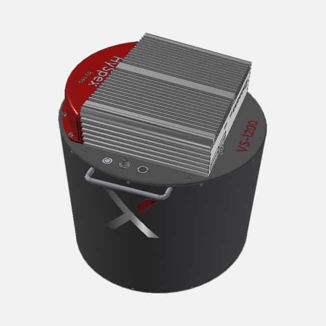
Die HySpex VS-1200 ist ein neuartiges, hochauflösendes Instrument, das für luftgestützte Anwendungen in Höhen von mehr als 400 m konzipiert wurde. Die Kamera erzeugt Daten auf höchstem wissenschaftlichem Niveau, die im Handel erhältlich sind, mit einer FWHM von weniger als 1,2 Pixeln im räumlichen und weniger als 1,5 Pixeln im spektralen Bereich. Der kombinierte VNIR-SWIR-Würfel weist Co-Registrierungsfehler sowie Smile und Keystone von weniger als 10 % eines Pixels auf.
Mit einem Sichtfeld von 40 Grad ist die Kamera ideal für die Kartierung großer Gebiete mit hoher Genauigkeit und Auflösung.
Die Kamera wird standardmäßig mit einer integrierten Hochleistungs-IMU/GPS und Datenerfassungseinheit mit Wechselspeicherschächten geliefert. Vorhandene Navigationssysteme können ebenfalls integriert/verwendet werden.
Eine passive Dämpfungslösung ist standardmäßig im Lieferumfang enthalten, Montageplatten für aktive Dämpfungslösungen wie GSM4000 oder PAV80 können jedoch geliefert werden.
Das HySpex Classic VS-1200 Sortiment im Überblick
V-2400 | S-1200 | |
Spektralbereich | 400 – 1000 nm | 950 – 2500 nm |
Kombinierter Spektralbereich | 400 – 2500 | 400 – 2500 |
Räumliche Pixel | 2400 | 1200 |
Kombinierte räumliche Pixel | 1200 | 1200 |
Räumliche Auflösung (Pixel) | FWHM < 1.2 | FWHM < 1.2 |
Spektrale Kanäle | 400/200 | 300 |
Kombinierte Spektralkanäle | 680/490 | 680/490 |
Spektrale Auflösung (Pixel) | FWHM < 1.5 | FWHM < 1.5 |
F-Nummer | F1.8 | F1.9 |
FOV | 40° | 40° |
Kombiniert FOV | 40° | 40° |
Pixel FOV quer/lang | 0.27/0.54 mrad | 0.54/0.54 mrad |
Kombinierte Pixel FOV quer/lang | 0.54/0.54 mrad | 0.54/0.54 mrad |
Bit-Auflösung (Rohdaten) | 12 Bit | 16 Bit |
Grundrauschen | 2.4 e- | 80 e- |
Dynamischer Bereich | 4400 | 10000 |
Peak SNR (bei voller Auflösung) | > 180 | > 900 |
Peak SNR (merged cube) | > 240 | > 900 |
Max. Geschwindigkeit (bei voller Auflösung) | 285 fps | 100 fps |
Stromverbrauch | 150 W | 150 W |
Abmessungen (⌀–h) | 373 – 398 mm | 373 – 398 mm |
Gewicht | ~ 35 kg | ~ 35 kg |
Field of View Expander – The field expander doubles the pixel FOV (along and across track) as well as the total FOV of the camera. The field expander is easily mounted onto the camera by the user, and is available for all classic HySpex models.
Navigation Systems – A GPS/IMU system continuously logging the position and attitude of the HySpex sensor is essential in order to perform precise georeferencing of airborne hyperspectral imagery.
Airborne Data Acquisition Units – To accommodate any aircraft platform preferred by the end-user, NEO offers a selection of DAUs ranging from ultra-compact, low power DAUs to 19” rack solutions.
PARGE® is the orthorectification and direct geocoding software for airborne optical scanner data. It performs an ortho-rectification of line scanner imagery using a digital elevation model on the basis of high precision flight parameters such as GPS position and attitude angles. Using accurate digital elevation models and optional ground control points, sub-pixel geometric accuracy is achieved. The program is suited for the correction of all kinds of airborne scanner imagery and is optimized for airborne hyperspectral instruments.
The software offers these key advantages:
The airborne ATCOR® (ATCOR-4) is used for atmospheric correction of small and wide FOV sensors. For computational efficiency, there are separate modules for flat and rugged terrain imagery. A large „monochromatic“ database of atmospheric correction functions comes with the ATCOR-4 model. The database was compiled with the Modtran®-5 code (DISORT, 8 stream option). It comprises the altitudes 0 km to 10 km and 20 km (1 km increment, with occasional larger gaps). For a given sensor and range of operating altitudes, the corresponding altitude files from the monochromatic database have to be resampled with the spectral filter functions of all channels.
The achievements of ATCOR-4 are:
Besides atmospheric correction, the surface reflectance cube retrieved from airborne data may be used to simulate top-of-atmosphere (TOA) radiance scenes with an ATCOR-4 add-on module. This is a convenient way to provide realistic data for a spaceborne version of an airborne instrument. Atmospheric parameters and the solar geometry can be varied and the resulting effect can be observed in the TOA radiance scene. After calculating the TOA radiance cube from hyperspectral imagery there is the possibility of synthesizing new hyper- or multi-spectral scenes with appropriate spectral resampling.
High resolution and high speed, combined with low weight and power consumption, make HySpex cameras very well suited for airborne data acquisition. A typical airborne installation consists of the HySpex cameras coupled with an airborne data acquisition unit, a navigation system (IMU/GPS) and a mounting platform. Both actively stabilized and passively damped mounting platforms can be supplied, as well as standard mounting plates with no damping. IMU/GPS solutions from leading manufacturers can be supplied and integrated with the cameras. Alternatively, HySpex systems can be interfaced with the customer’s existing navigational hardware.
Vielen Dank!
Ihre Anfrage wurde erfolgreich übermittelt.
Produktanfrage
Bitte füllen Sie alle erforderlichen Felder aus.*